by Guest » November 30, 2021, 6:17 pm
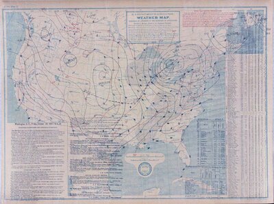
I grabbed the Daily Weather Map for October 20, 1905 from NOAA, converted it from .pdf to a .jpeg, did some editing in Adobe Photoshop to fix the white-balance and bring out the isobars for clarity.
It's hard to get the full picture of either system unless one does a full analysis as so much data is missing. One needs to use re-analysis datasets from Europe or NCEP, due to the scarcity of surface observations and the frequency of the maps. (Much is missed when you only have a 24-hour chart, as what happens between that time is often far more important.) I hope to do a numerical weather prediction model simulation of the November 27-29, 1905 system in the near future.
When you look at the November 27-29, 1905 and the October 19-20, 1905 systems, they are not unusual in terms of intensity based on my experience in meteorology.
Meteorology was in its infancy in the early 20th Century and so our knowledge of the interaction between the heat storage of the lakes and a cold air mass moving over the lakes was limited to non-existent. What we've learned through research and observation over the decades is that a cold air mass moving over the Great Lakes can generate vertical air motions and the greater the temperature difference between lake temperature and and temperatures at 1 to 2-km above the surface causes instability; allowing winds in the higher atmosphere to mix/migrate down to the lake. It can also cause waves to be higher than would be expected for a given wind speed.
The weather map for November 28, 1905, shows winds from the northeast across most of Lake Superior, and with such a long fetch, the waves would grow in size, especially in extreme western Lake Superior - which is where the majority of the shipwrecks occurred.
- Brian
- Attachments
-

I grabbed the Daily Weather Map for October 20, 1905 from NOAA, converted it from .pdf to a .jpeg, did some editing in Adobe Photoshop to fix the white-balance and bring out the isobars for clarity.
It's hard to get the full picture of either system unless one does a full analysis as so much data is missing. One needs to use re-analysis datasets from Europe or NCEP, due to the scarcity of surface observations and the frequency of the maps. (Much is missed when you only have a 24-hour chart, as what happens between that time is often far more important.) I hope to do a numerical weather prediction model simulation of the November 27-29, 1905 system in the near future.
When you look at the November 27-29, 1905 and the October 19-20, 1905 systems, they are not unusual in terms of intensity based on my experience in meteorology.
Meteorology was in its infancy in the early 20th Century and so our knowledge of the interaction between the heat storage of the lakes and a cold air mass moving over the lakes was limited to non-existent. What we've learned through research and observation over the decades is that a cold air mass moving over the Great Lakes can generate vertical air motions and the greater the temperature difference between lake temperature and and temperatures at 1 to 2-km above the surface causes instability; allowing winds in the higher atmosphere to mix/migrate down to the lake. It can also cause waves to be higher than would be expected for a given wind speed.
The weather map for November 28, 1905, shows winds from the northeast across most of Lake Superior, and with such a long fetch, the waves would grow in size, especially in extreme western Lake Superior - which is where the majority of the shipwrecks occurred.
- Brian